Alaska-Canada Adventure Ride
Day 27 - 29 - Lewiston, Idaho to Bend, Oregon, Mt Shasta, California,
and Sacramento, California
(899
miles)
 Day
27
Day
27
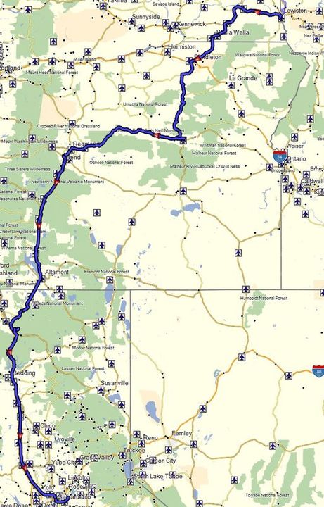
The plan for the day was to head east on Highway 12 to Walla Walla, Washington, then picking up Highway 395 in Pendleton, Oregon, head south to Mt Vernon, and then take Highway 26 west towards Bend. In this manner we got to ride mostly back roads, but still maintain a fast pace, and still on a relatively direct route.
This ride ended up being reasonably scenic, with the most interesting sections between Pendleton and Prineville on 395 and 26. The area is fairly remote and bucolic, with hardly any other vehicle traffic present. There are some charming small towns with a rural flair along the way, stopping at one for lunch called Long Creek. I could see coming through the Highway 395 corridor for this portion of eastern Oregon again in the future and camping in the area.
After getting to Prineville, traffic starts to pick up. The growth of the metropolitan area between Bend and Prineville has be very high over the last decade, as evident by the amount of new urban sprawl present. Apparently Facebook has just established a new data center in Prineville.
We ultimately found one of the last campsites at Tumalo State Park just north Bend. Compared to the places we have been camping, this one was relatively high in density with more pavement and people then grass and dirt. But at this point, it didn't matter much, as it had showers and a place to pitch a tent, while we would be just be moving on the first thing in the morning.
Day 28
On the next morning Tucker parted ways with us, deciding to take a longer coastal route home via Highway 1. His thoughts were that it will be cooler and more scenic then the direct path that Randy and myself planned on Highway 97 and I-5. The challenge that our latter route faced was the 105+ degree heat in the valley from Redding to Sacramento. With that in mind we decided to break it up into two shorter days to avoid this afternoon heat, camping on the slopes of Mt. Shasta at the Bunny Flat dry camp area we have used before.
Arriving at Bunny Flats in the early afternoon, we realized finding an open camp site to be a bit trickier than expected due to a number of hikers staging from this area to climb Mt. Shasta. The off-road capabilities of our adventure motorcycles had to be used one more time to find a suitable place to pitch our tents. This "campground" area has gone downhill since my last visit. Much more crowded, bathroom facilities were locked, and the host that used to be here to keep things in check was gone.
In hindsight, it probably would have been best to just keep going on the previous day, find something further south, or just endure the valley heat for a longer ride home, instead of breaking it up into two days. Another alternative that would have been probably better is to have stayed on Highway 395/89 heading south all the way to Truckee, and then cut west to Sacramento.
Day 29
The next day we were back in Sacramento before noon. After counting more CHP on the road the last couple days than we saw police troopers on the entire trip, it just reaffirmed my views about how California tax dollars are spent. Meanwhile Tucker returned the following day. After unable to find a campsite along the popular northern
California coast, he decided to just keep riding, getting back to the barn that
next night.
All content and images are property of Stephen Fischer Photography, copyright 2019 - 2020. Last updated: 1/10/2020