Alaska-Canada Adventure Ride
Day 11 - Inuvik, Northwest Territories to Tuktoyaktuk, Northwest Territories and back (188 miles)
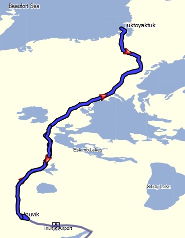 Leaving our camp setup in place, the plan was to ride to Tuktoyaktuk and back for the day. Given the good weather for the day, it looked like we would be able to get up there and have time to explore a bit without pressure of the roads turning bad
and with a lighter load on our bikes.
Leaving our camp setup in place, the plan was to ride to Tuktoyaktuk and back for the day. Given the good weather for the day, it looked like we would be able to get up there and have time to explore a bit without pressure of the roads turning bad
and with a lighter load on our bikes.
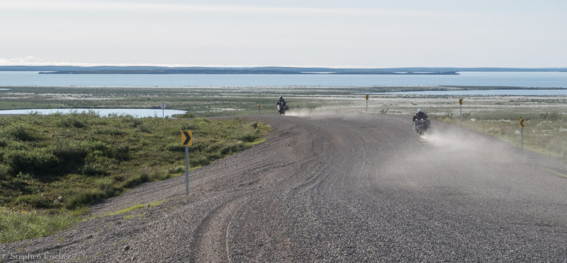
The going for this last 94 miles was fairly smooth for the first half, but closer to Tuktoyaktuk there was of an excessive amount of gravel laid down on the road. It appears the road department got the memo about preventing mud, but not the one about the importance of compacting the gravel. As a result, some of the corners, especially on the downhills could be real nail biters as you try to keep the bike upright. I kept looking for more compacted wheel tracks to ride in to minimize this hazard, while also trying to keep the speed up on the straight-aways in order to better surf on top of it. Locking my steering stabilizer to the max seemed to help me in a few situations where the front wheel wanted to deflect in some of the deeper gravel.
Just before reaching Tuktoyaktuk, one will notice these unusual volcanic shaped mounds out toward the edge of the Arctic Sea. These are called Pingos by the locals. They are formed by frozen water underneath the surface that pushes the land up as the ice expands. Through an iterative process each year, more and more of the land is pushed upward out of the water saturated ground, creating these unusually shaped hills that are uncharacteristic to the rest of the surrounding landscape.
Getting into the town of Tuk I was greeted by a welcoming committee in the form of a water truck that quickly pulled out in front of me and started to spray water on a somewhat already muddy road. The result was a road that seemed as slippery as whale blubber, causing me to just temporarily pause to pick a safer path around it. This seemed maddening given I did not see any dust that needed controlling, with potentially the only outcome was to cause the crash of yet another adventure motorcyclist doing their pilgrimage to this infamous location.
After reaching the Arctic Ocean sign and getting some photos, I spent a bit of time exploring the village, also stopping at the visitor center shack to get the badge of honor in the form of the Tuk sticker. Some of the riders went over to the popular Mom's Kitchen for lunch, while I bought something from the local general store. Mom's Kitchen is known for its relatively exotic food (e.g. Whale sandwich) that you will not so easily find at points further south. It is located in a typical single-wide building at the water's edge close to the "campground". Back in Inuvik we were warned about this "campground" by a local, being overpriced with no real facilities and just a flat spot on the ground amongst the driftwood and sand. Sad to say, but the reports were true.
When looking back at the initial planning for this ride, I expected that by Tuktoyaktuk, we would have to be prepared for some extreme weather. Given we were at the most northerly road accessible town in Canada (and just slightly lower latitude than Prudhoe Bay), it was kind of shocking that it ended up being warm enough for just a T-shirt. One of our riders Vicki, also used this as an opportunity to do a bit of swimming in the Arctic Ocean. I had also inquired earlier if we needed to worry about polar bears in the summer if camping here. But given no ice or snow as far as I could see, and water warm enough to swim in, it seems like such a silly question now. Who says that climate change is a Chinese hoax?
Images (click to select the larger view at bottom)


All content and images are property of Stephen Fischer Photography, copyright 2019 - 2020. Last updated: 1/10/2020